|
|
|
THE 12 BEST DANISH CLIMBS
The website Danskebjerge.dk has picked the 12 toughest and best climbs on Danish roads. This is the complete list.
[Please notice: An updated and revised version of this list has been created. Go to the new official list HERE.]
The climbs are ranked in accordance with a rating system that specifies the degree of difficulty. However, several criteria play a role in the assessment of a climb. Read about criteria and definitions at the bottom of this page.
Probably, there are many different opinions out there about climbs, and this pick is, of course, not the only truth. But Danskebjerge.dk has tried to make the criteria as clear and objective as possible.
1.
|
VANG
Landscape: Bornholm
|
Start
(masl.) |
End
(masl.) |
Diff. in height |
Length
(m) |
Gradient
(average) |
Rating
|
The hill on a
MAP
|
|
2,50
|
94,25
|
91,75
|
1280
|
7,2%
|
157,5
|
|
|
Facts about the climb:
The hill begins in the small seaport of Vang. There are some big turns on the way, including a hairpin bend after 200 meters. In the outskirts of Vang, the climb evens out a bit. The top is reached shortly before Borrelyngvej. The climb has a blind start - however, Vang can be reached via paths from the south.
|
A rider's description:
"This climb is the toughest on Bornholm. People tend to 'boil over' already after that first bend. The average grade is not as extreme as on for example the Helligpeder hill, but it's really long, and the difference in height is considerable. Vang is included in the 'Champion of the Mountains' race on Bornholm, and no doubt the lighter riders have an advantage here." (Ole Karpf, Rønne)
|
|
Estimation
|
Toughness
|
Steepness
|
Aesthetics
|
Ridability
|
Overall
|
MOST DEMANDING!
|

|
|

|

|
|
|
2.
|
JELLINGVEJ
Landscape: Vejle Fjord
|
Start
(masl.) |
End
(masl.) |
Diff. in height |
Length
(m) |
Gradient
(average) |
Rating
|
The hill on a
MAP
|
|
2,50
|
106,50
|
104,00
|
2050
|
5,1%
|
156,8
|
|
Hill profile at Salite.ch
|
Facts about the climb:
This long hill starts in Enggade, continues along Jellingvej and peaks on Petersmindevej at Stjernevej. You are primarily moving in a north-western direction. During the climb, you must cross Jellingvej twice. The main part of the hill is situated in an urbanised area with some traffic.
|
A rider's description:
"Jellingvej is something quite special. After a long, straight part you arrive at the 'forest line' where the road starts to twist spectacularly. You feel the climb go on and on. Then you cross to the left and approach the final which is the steepest part of the hill, too. Even if you keep a moderate rhythm, you'll feel pretty used up once arriving at the Petersminde School at the top." (Troels Vesterlund, Vejle)
|
|
Estimation
|
Toughness
|
Steepness
|
Aesthetics
|
Ridability
|
Overall
|
TOUGHEST!
|
|
|
|
|
|
|
|
3.
|
MUNKEBJERG
Landscape: Vejle Fjord
|
Start
(masl.) |
End
(masl.) |
Diff. in height |
Length
(m) |
Gradient
(average) |
Rating
|
The hill on a
MAP
|
|
2,50
|
92,75
|
90,25
|
1270
|
7,1%
|
154,4
|
|
Hill profile at Salite.ch
|
Facts about the climb:
Situated on the slope that follows the south side of Vejle Fjord, this hill begins where Ibæk Strandvej breaks right and becomes Munkebjergvej. Early on the hill, you will pass under a railway bridge with traffic lights. You'll primarily go south, but you will be meeting some solid turns on the way. The top is found next to the parking lot of the Munkebjerg Hotel.
|
A rider's description:
"The presence of history sticks to the asphalt of this wellknown hill. After the famous hairpin turn which makes me quite high on the bike, the light-green beech leaves are succeeded by pine trees, and the final is getting closer: A climb at up to 16 percent grade - here you'll be surprised that even a moderate initial speed will prove costly. - Munkebjerg is a must for all serious bike riders in Denmark." (Troels Vesterlund, Vejle)
|
|
Estimation
|
Toughness
|
Steepness
|
Aesthetics
|
Ridability
|
Overall
|
THE BEST!
|
|
|
|
|
|
|
|
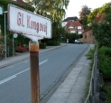
4.
|
GL. KONGEVEJ
Landscape: Vejle Fjord
|
Start
(masl.) |
End
(masl.) |
Diff. in height |
Length
(m) |
Gradient
(average) |
Rating
|
The hill on a
MAP
|
|
2,50
|
79,00
|
76,50
|
790
|
9,7%
|
150,6
|
|
Hill profile at Salite.ch
|
Facts about the climb:
The lowest point of the hill is situated on Enggade, but it's from the crossing Jellingvej-Gl. Kongevej that the climb is most demanding. The road turns twice and ends on Chr. Winthers Vej, Denmark's steepest street. Riding down these two streets is prohibited - because of the steepness!
|
A rider's description:
"There's not much to add: The Kongebakken (King's Hill) is just fatal. Here we're dealing with a hill of a quite different category than other wellknown hills in Denmark: there is a difference between riding up a hill while finding an adequate speed - and, on the other hand, Gl. Kongevej which can only be climbed in one way: the way that prevents you from stalling. Here, there is no mercy if you're already aching after a long ride."
(Troels Vesterlund, Vejle)
|
|
Estimation
|
Toughness
|
Steepness
|
Aesthetics
|
Ridability
|
Overall
|
STEEPEST!
|
|
|
|
|
|
|
|
5.
|
HIMMELBJERGET
Landscape: Søhøjlandet
|
Start
(masl.) |
End
(masl.) |
Diff. in height |
Length
(m) |
Gradient
(average) |
Rating
|
The hill on a
MAP
|
|
52,25
|
141,50
|
89,25
|
1430
|
6,2%
|
145,0
|
|
|
Facts about the climb:
The climb is situated on the paved part of Bøgedalsvej. The top of the hill is found just before the crossing at Himmelbjergvej. On the way up, you mainly move to the south-east. On the whole stretch, you're surrounded by forest (Rye Nørreskov).
|
A rider's description:
"Bøgedalsvej is basically one long climb which many bike riders would have used had it not ended in a gravel road in the one end. The paved climb is almost straight, but small vertical and horisontal bends make it impossible to look more than a few hundred meters ahead. The ascend is moderate on the first 400 meters, after which it gets pretty steep the rest of the way - so yet another hill where you must spend your energy wisely." (Ole Thisted, Skanderborg)
|
|
Estimation
|
Toughness
|
Steepness
|
Aesthetics
|
Ridability
|
Overall
|
LONG AND TIRING
|
|
|
|
|
|
|
|
6.
|
J. JEPSENS VEJ
Landscape: Vejle Fjord
|
Start
(masl.) |
End
(masl.) |
Diff. in height |
Length
(m) |
Gradient
(average) |
Rating
|
The hill on a
MAP
|
|
20,75
|
96,75
|
76,00
|
840
|
9,0%
|
144,8
|
|
|
Facts about the climb:
This climb is parallel to the neighbouring climb at Østengård and thus rises towards north. It starts to go upwards at Knabberupgård. Right at the top, the asphalt is succeeded by a gravel road.
|
A rider's description:
"Julius Jepsens Vej can only be described by one word: Chaos. It is really narrow and winding - and with bumpy asphalt that disturbs the rhythm. The hill has similarities to the worst climbs of Giro d'Italia which are reputed for being hard to pass. Yet, this hill is something special - your senses are being put to the test and the troll-like design is playing games with your pulse each time Mr Jepsen welcomes you." (Troels Vesterlund, Vejle)
|
|
Estimation
|
Toughness
|
Steepness
|
Aesthetics
|
Ridability
|
Overall
|
SHADOWY AND OCCULT
|
|
|
|
|
|
|
|
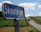
7.
|
YDING SKOVHØJ
Landscape: Søhøjlandet
|
Start
(masl.) |
End
(masl.) |
Diff. in height |
Length
(m) |
Gradient
(average) |
Rating
|
The hill on a
MAP
|
|
80,00
|
169,00
|
89,00
|
1670
|
5,3%
|
136,4
|
|
Hill profile at Salite.ch
|
Facts about the climb:
This climb lies on Skovhøjvej which - as the name suggests - leads up to Yding Skovhøj, one of the very tallest points in Denmark. The road ascends first towards south-east, later east. At the start, you are surrounded by fields, but about halfways the forest Yding Skov emerges to your left. The top is reached close to Yding Skovhøj. The road conditions are generally fine.
|
A rider's description:
"A climb which the tour leaders of the bicycle club really fancy. After you've turned off at Ydingvej, it begins to go upwards after two sharp bends. The ascend is steady, until passing Løkkevej where the climbs gets a little steeper. At Hovgårdsvej the road twists a bit - and then goes steeply upwards on the final part."
(Jeannie Outsen, Skanderborg)
|
|
Estimation
|
Toughness
|
Steepness
|
Aesthetics
|
Ridability
|
Overall
|
DENMARK's HIGHEST
|
|
|
|
|
|
|
|
8.
|
ØSTENGÅRD
Landscape: Vejle Fjord
|
Start
(masl.) |
End
(masl.) |
Diff. in height |
Length
(m) |
Gradient
(average) |
Rating
|
The hill on a
MAP
|
|
24,75
|
100,00
|
75,25
|
930
|
8,1%
|
136,1
|
|
Hill profile at Salite.ch
|
Facts about the climb:
This stretch begins right north of the small Vejle suburb of Østengård and continues north towards Høgsholt. Almost the entire climbs lies on a fairly narrow road in Østengård Skov. You arrive at the top shortly after a sharp turn to the right.
|
A rider's description:
"After the steepest part of the hill at around 17 %, the hill descends a bit, and you feel that the first stretch has been somewhat redundant to reach the top. But this totally uneven part leaves its mark on your rhythm on the final long stretch at 8 %. A surreal experience is the encounter with Scottish Highland Cattle that are standing just before the top with their develish horns and long brown hair gaping at the suffering bike riders who fight to maintain their morale." (Troels Vesterlund, Vejle)
|
|
Estimation
|
Toughness
|
Steepness
|
Aesthetics
|
Ridability
|
Overall
|
LEGENDARY
|
|
|
|
|
|
|
|
9.
|
YPNASTED
Landscape: Bornholm
|
Start
(masl.) |
End
(masl.) |
Diff. in height |
Length
(m) |
Gradient
(average) |
Rating
|
The hill on a
MAP
|
|
4,00
|
87,00
|
83,00
|
1510
|
5,5%
|
128,6
|
|
|
Facts about the climb:
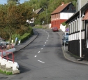
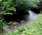
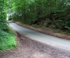
This one is situated right between the towns of Svaneke and Gudhjem. It starts blindly down at the water on the small road Ypnasted and continues south to Bølshavn (as on photo). Here, you turn right and go on westward up Randkløvevej until you reach a farm called Søborg. If you omit the first stretch on the small road, the height of the climb is reduced by 23 meters.
|
A rider's description:
"When there is a race, the field often splits into two on this hill. The fastest will accumulate a good lead here and then give it full throttle as it goes down again right after the peak. - However, this is not my favourite hill. It has no really steep parts, and you can keep a steady speed all the way. Besides, it's a main road with trucks and often some slow-going tourists."
(Ole Karpf, Rønne)
|
|
Estimation
|
Toughness
|
Steepness
|
Aesthetics
|
Ridability
|
Overall
|
BORNHOLM's MOST FAMOUS
|
|
|
|
|
|
|
|
10.
|
VEJRHØJ
Landscape: Vejrhøj-buen
|
Start
(masl.) |
End
(masl.) |
Diff. in height |
Length
(m) |
Gradient
(average) |
Rating
|
The hill on a
MAP
|
|
16,25
|
94,50
|
78,25
|
1250
|
6,3%
|
127,2
|
|
|
Facts about the climb:
The road starts to go upwards in Vindekilde on Kolåsvej at the farm Rødegård. Shortly after you turn left and continue northward along Vejrhøjvej. You will pass through Vejrhøj Skov and arrive at Vejrhøjgård just after a turn to the left, this being the end of the gravel part of the climb. From here, a path goes on to the brial mound on the top.
|
A rider's description:
"Vejrhøj is the most imposing hill on Zealand, and therefore it's obviously a big triumph to be able to ride almost to its peak. The part in the forest is the most challenging, but it never gets really steep. The main disadvantages of Vejrhøjvej is that it ends blindly, and that there are some irritating speed humps on the way, mainly being a problem on the descend."
(Danskebjerge.dk)
|
|
Estimation
|
Toughness
|
Steepness
|
Aesthetics
|
Ridability
|
Overall
|
TOUGHEST ON ZEALAND
|
|
|
|
|
|
|
|
11.
|
HELLIGPEDER
Landscape: Bornholm
|
Start
(masl.) |
End
(masl.) |
Diff. in height |
Length
(m) |
Gradient
(average) |
Rating
|
The hill on a
MAP
|
|
2,50
|
83,75
|
81,25
|
1490
|
5,5%
|
125,6
|
|
|
Facts about the climb:
The climb begins at the harbour at Helligpeder. You proceed up Helligpedervej and turn left at Borrelyngvej on which you'll reach the top after around 500 meters. The road is relatively narrow at first, and there are a couple of sharp turns. The primary ride direction is east.
|
A rider's description:
"The hill really goes up from the start: 14 %. Here, you must avoid getting so much lactic acid in your legs that you're down and out when the gradient is reduced a bit further ahead. An "extenuating circumstance" for this tough hill is the fact that you'll often get the west wind from behind. - If you use the road as a descend, you need to be careful. It has occured that a rider has ended up in the ocean."
(Ole Karpf, Rønne)
|
|
Estimation
|
Toughness
|
Steepness
|
Aesthetics
|
Ridability
|
Overall
|
BRUTAL START
|
|
|
|
|
|
|
|
12.
|
HØJEN SKOVVEJ
Landscape: Vejle Fjord
|
Start
(masl.) |
End
(masl.) |
Diff. in height |
Length
(m) |
Gradient
(average) |
Rating
|
The hill on a
MAP
|
|
5,25
|
81,0
|
75,75
|
1180
|
6,4%
|
124,4 |
|
|
Facts about the climb:
The climb takes off right after you turn from Ribe Landevej on to Højen Skovvej. Then you pass through the forest Højen Skov. When you leave the forest again, the hill gets flatter, and only a few vertical meters remain. Almost all the way, you are moving south.
|
A rider's description:
"Højen Skovvej goes up and up, at a grade of 12 to 8%, and the very narrow road has similarities to a climb in the Ardennes in a classic cycle race. In fact, Johan Museeuw himself climbed this hill in 2003 and later won the stage to Kolding in the Tour of Denmark. So go for a ride to the Ardennes on Højen Skovvej." (Troels Vesterlund, Vejle)
|
|
Estimation
|
Toughness
|
Steepness
|
Aesthetics
|
Ridability
|
Overall
|
A TITBIT FOR THE EXPERTS
|
|
|
|
|
|
|
|
Criteria:
To enter the Top 12, the following criteria must be met:
The hill must have a grade of at least 5 % in average
The total ascend must exceed 75 meters vertically from bottom to top
The whole climb must lie on a public, paved road
The hill is measured according to its total size. That means that the bottom is the place where the hill has its lowest point, and where the terrain previous to this point is higher or almost flat. Accordingly, the top is the place where the highest point of the hill is found, and where the terrain after this point is lower or almost flat.
Definitions:
Toughness: The size of the hill, measured from the number of height meters to be overcome from bottom to top. A difference in height of 75 to 85 meters generates 1 hill, 85 to 95 meters give two, and everything beyond that results in 3 hills.
Steepness: The difficulty of the steepest parts of the hill. A steepness of up to 10 % will typically result in 1 hill, 10-15 % means 2, while even higher gradient percentages yield 3 hills.
Aesthetics: The competitive challenge you meet on the hill, combined with the visual impression of the course and its surroundings.
Ridability: The simplicity of the stretch and the absence of conditions that can hamper a cyclist (crossings, blind streets, etc.).
Overall: A total mark for the hill as defined by the four parameters.
For every parameter, a number of "hills" are assigned where 0 is the worst and 3 the best. Notice, however, that every hill in Top 12 is unusually tough and steep on a Danish scale, no matter what marks it is given.
Rating:
The rating system on Danskebjerge.dk is an attempt to create a framework for comparing climbs. The system is based on the following formula:
Average gradient * ( 1+ (average gradient / steepness index) * length)
Thus, the rating primarily rests on the two basic parameters: how steep is the hill, and how long is it? But the "steepness index" (which is set to 10) means that particularly steep hills get a relatively higher rating than those that are a little less steep.
However, the rating does not count in exact details of the the different climbs. For instance, the maximum gradients are not included in the calculation.
All photos: Danskebjerge.dk
|
| | | | | | | | | | | | |